Kurdish fighters walk near the town entrance circle in route to their strongholds in Kobani, Syria, on November 19, 2014. Jake Simkin/AP
The Syrian Civil War, From Space
Three years of conflict have literally plunged the country into darkness. By Uri Friedman
The ruin brought about by Syria's civil war is difficult to fathom—not only because the death toll is so numbingly high , but because the numbers themselves are so fuzzy. This week, for example, we learned that more than 200,000 people have now died in the three-and-a-half-year conflict—except that the figure, as The Washington Post noted, comes from an opaque organization based in Coventry, England that won't share the data or methodology it uses to arrive at its tally. All sides in the war quibble over the number, but there are few alternatives. At one point earlier this year, even the United Nations stopped counting the dead .
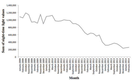
This fall, researchers at Wuhan University in China took an unconventional approach to capturing the devastation: In a study for the International Journal of Remote Sensing , Xi Li and Deren Li bypassed the death toll altogether, instead turning to U.S. satellites hovering more than 500 miles above the earth's surface. The view of Syria from space, they argued, provides "one of the few sources of objective information" on the crisis. Assessing composite satellite images, they concluded that nighttime light declined by around 74 percent across Syria between March 2011 and February 2014. The exceptions were Damascus, the capital, and Quneitra, near the Israeli border , where the levels of light at night decreased by roughly 35 percent. Syria, in other words, is shining just a quarter as bright as it was before the war.
The images above depict nighttime light in Syria in March 2011, when the Syrian uprising began, and February 2014. You can see how the lights have dimmed dramatically in cities like Aleppo and across the nation, especially when you compare the country with neighbors like Turkey (north of Syria) and Lebanon, Israel, and Jordan (to the west and south), where the light patterns remain essentially the same across the three-year period. In hard-hit Aleppo, the authors write, nighttime light has fallen by a staggering 88 percent.
The following graph tracks changes in light over time, as measured by pixels in the satellite images that the authors evaluated:
Nighttime Light in Syria, January 2008 - February 2014

.jpg)
Nighttime light in Syria, as viewed from space in March 2011 (top image) and February 2014 (bottom) ( Xi Li/Deren Li )
The darkness signals not only death and destruction—things like diminished human activity, depleted power supplies, demolished buildings—but also displacement. Nearly half of Syria's population has been uprooted since 2011, and lights fade when people flee their homes. The researchers found a correlation between the number of internally displaced persons (IDPs) from each province and the amount of nighttime light loss.
The Syrian war is a humanitarian emergency . It's a new front in the U.S. military's campaign against terrorism . And it's also one of the world's most glaring blind spots. With so few journalists in the country, satellites have offered an alternative (if flawed and depressingly distant) means of bearing witness, monitoring everything from the movement of chemical weapons to the growth of refugee camps to damage to historic landmarks .
But Xi Li and Deren Li see a broader application for their findings. Satellite images of nighttime lights are a rough, emerging technology, the authors concede, but they're also relatively cheap data sources for comprehending conflicts. Better understanding the relationship between displaced people and declines in light, for instance, could help researchers estimate the number of people who are fleeing violence in a given country or region. Sometimes the clearest views of war come from hundreds of miles above ground.


